Project Description
About a year ago, we published an article (see [1]) briefly describing the concept behind the exploitation of a UAV for the enhancement of earth observation data collected by satellite constellations. Since then, considerable progress has been made, mainly towards the UAV application in the wide area of crop monitoring, where a set of official mission flight operations have already been conducted (Pilot Use Case 1). Now that we are in the third year of the CALLISTO project and on the way to its completion, the preparation of two sets of official mission flight operations (for PUC1 and PUC4) is in progress. But before going into more analysis about the planned applications, let’s have a look at the specifications of the UAV designed and manufactured by ACCELI based on the requirements defined for the project, and specifically according to the needs that were set for each PUC.
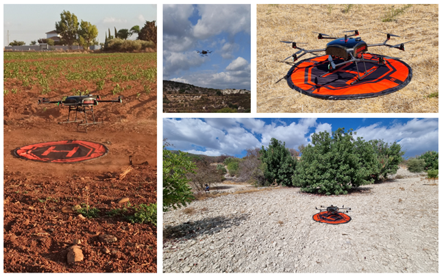
Figure 1 – PUC1: ACCELI’s UAV in operation (photo credits to: George Choumos [NOA] and Mr. Nicolaos Daniel [CAPO])
ACCELI’s UAV
The ACCELI’s UAV (Figure 1) is an octa-copter multirotor aerial vehicle that has been utilized for inspecting remote areas surrounding critical infrastructures to detect illicit activities or objects. The UAV is completely customizable, allowing for the incorporation of various hardware components and easy adaptation to the user’s current operations. It features a GNSS module for highly precise localization, a high-end multispectral camera sensor, and a distance sensor that accurately estimates its altitude. Additionally, the UAV is equipped with a companion computer that offers superior GPU capabilities, taking over the host and execution of AI algorithms for detecting and identifying objects, that require significant computational capacity.
PUC1: Pilot Test in Cyprus
If there is a discrepancy between farmers’ reported crop practices and satellite-based classification, a UAV will be deployed to conduct a high-resolution flight mission over the corresponding plots to obtain image data. After post-processing, this data will be used to extract ground truth information and aid payment agencies in determining whether subsidies should be granted or not. To test this concept, the official pilot test of PUC1 was conducted over a two-day period (October 6-7, 2022) in Cyprus using ACCELI’s UAV, during which six mission flights were conducted in various regions of the country. Each mission flight involved two main steps:
- Initially, the UAV was assigned a desired path, derived from a path planning algorithm based on the borders of the parcel, which was defined as a sequence of waypoints that were loaded onto the UAV’s autopilot.
- Subsequently, the UAV followed the flight plan, periodically capturing and storing an image along with corresponding metadata as it traveled from one waypoint to the next.
Figure 2 depicts the six images captured during the six mission flights. Additional mission flights in Cyprus are currently being prepared for the purposes of PUC1.

Figure 2 – PUC1: Images captured during the mission flights in Cyprus by the UAV’s multispectral camera
PUC4: (Upcoming) Pilot Test in Greece
The application of a UAV in PUC4 focuses on detecting changes along land borders. Its use in this task can aid in understanding the changes that occur by providing a data stream with better resolution and at different time frames, complementing the Earth observation data received from satellite constellations.
Preparations are currently underway to carry out a set of mission flights in Greece for PUC4. The flight scenario execution will be similar to that of PUC1, with the primary difference being that the collected data will be fed as a data stream to an object detection/recognition algorithm for real-time processing – this is a feature of ACCELI’s UAV that was not utilized in PUC1. The result of each flight will be a list of detected objects (buildings, bridges, parking lots and crossroads) along with their geographical coordinates.
Reference
[1] Oikonomou, P., 2022. UAVs: Towards the enhancement of earth observation data. link
