Project Description
A Hyperspectral Pointable System for Terrestrial and Aquatic Radiometry, HYPSTAR (www.HYPSTAR.eu), was installed at Blankaart WPC reservoir in January 2021 and continuously measures the upwelling and downwelling radiance and downwelling irradiance during daylight (7 a.m. till 6 p.m. local time). Mounted on a pan and tilt unit, the HYPSTAR recieves commands from the host system and returns measurements according to the defined measurement protocol (i.e., viewing geometries, number of scans, radiance or irradiance measurements, etc.).

Figure 1 – View from the north-east edge of the concrete wall in the Blankaart drinking reservoir (left), close-up on the HYPSTAR installed along the railing 30 m from the border edge (middle), and true color Sentinel 2A image acquired on 2021-02-04 and processed with ACOLITE with the Blankaart reservoir in the center of the image (top right) and the panchromatic GEOEye image acquired on 2019-05-24 (bottom right). A red cross indicates the location of the sensor (50.9888°N–2.8352°W). The blue semi-circle shows the orientation of the sensor during the day. Source: Goyens et al. (2022).
The HYPSTAR is an above water radiometer which means that, for the computation of the surface reflectance (i.e., how much light is reflected by the surface), it measures, just above the water surface, the light emitted by the surface, the so-called upwelling radiance (Lu), and the light received at the water surface, the so-called downwelling irradiance (Ed) (Fig. 2).
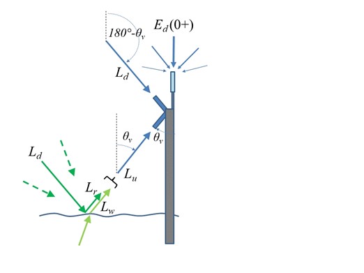
Figure 2 – Schematic of above-water radiometry with measurement of sky radiance, Ld and removal of the reflected skylight, Lr . Dashed arrows indicate that contributions to the skylight reflected at the air-water interface come from directions that are not directly measured by the L d radiance sensor, including possible contributions from the direct sunglint direction. Source: Goyens and Ruddick, 2023
For the estimation of the water reflectance, i.e., reflectance from the water and constituents within the water column, the surface reflectance needs to be corrected for the air-water interface reflectance. Indeed, the air-water surface acts like a mirror which reflects diffuse sky radiance and direct sunglint (Ld in Figure 2) according to the wave facets at the air-water interface. Numerous measurement protocols exist for the correction of the air–water interface reflectance for above-water acquisitions (Goyens and Ruddick, 2023 and references therein). However, the correction of the air-water interface reflectance remains a challenging task in above water radiometry. For the water quality monitoring above the Blankaart reservoir, we only focus on the high-quality data and ignore all the measurements with high uncertainty in the air-water interface reflectance. Thanks to the very high acquisition rate (~15 min) of the HYPSTAR instrument, the number of valid measurements remains still consequent and high temporal resolution time series of water quality products can be computed such as Chlorophylle-a (Fig. 3) and Suspended Particulate Matter (SPM) (Fig. 4).
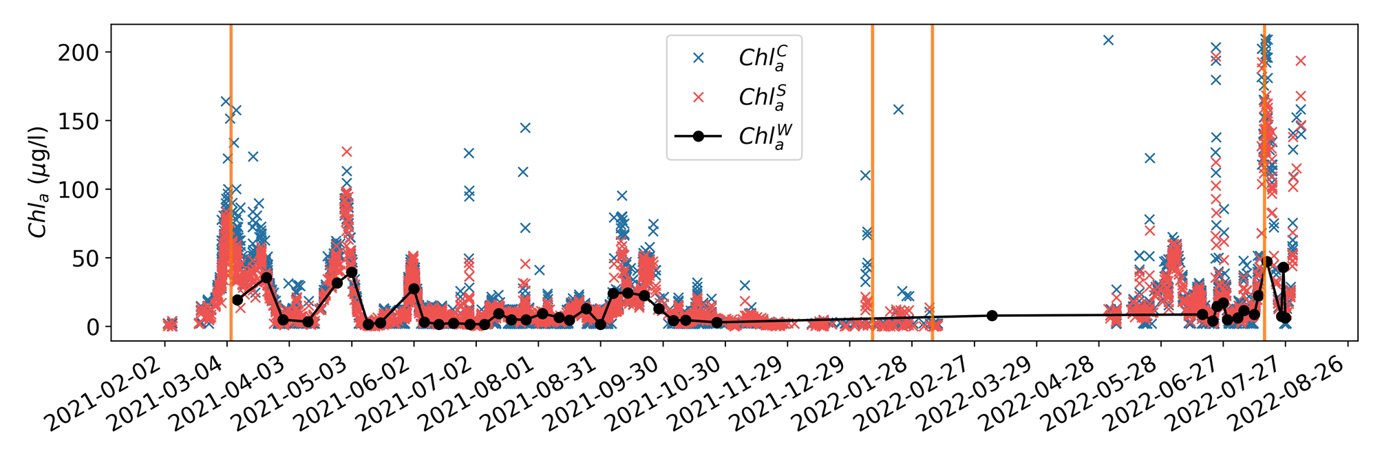
Figure 3 – Time series of HYPSTAR-retrieved Chla concentrations using CRAT and SIMIS algorithms (blue and red dots, respectively), and Chla concentrations measured from the water sampling points (black) between January 2021 and August 2022. Orange vertical bars point to specific dates with high SPM values, see Fig. 4, i.e., 2021-03-06, 2022-02-07, 2022-01-10, and 2022-07-17. Source Goyens et al., 2022
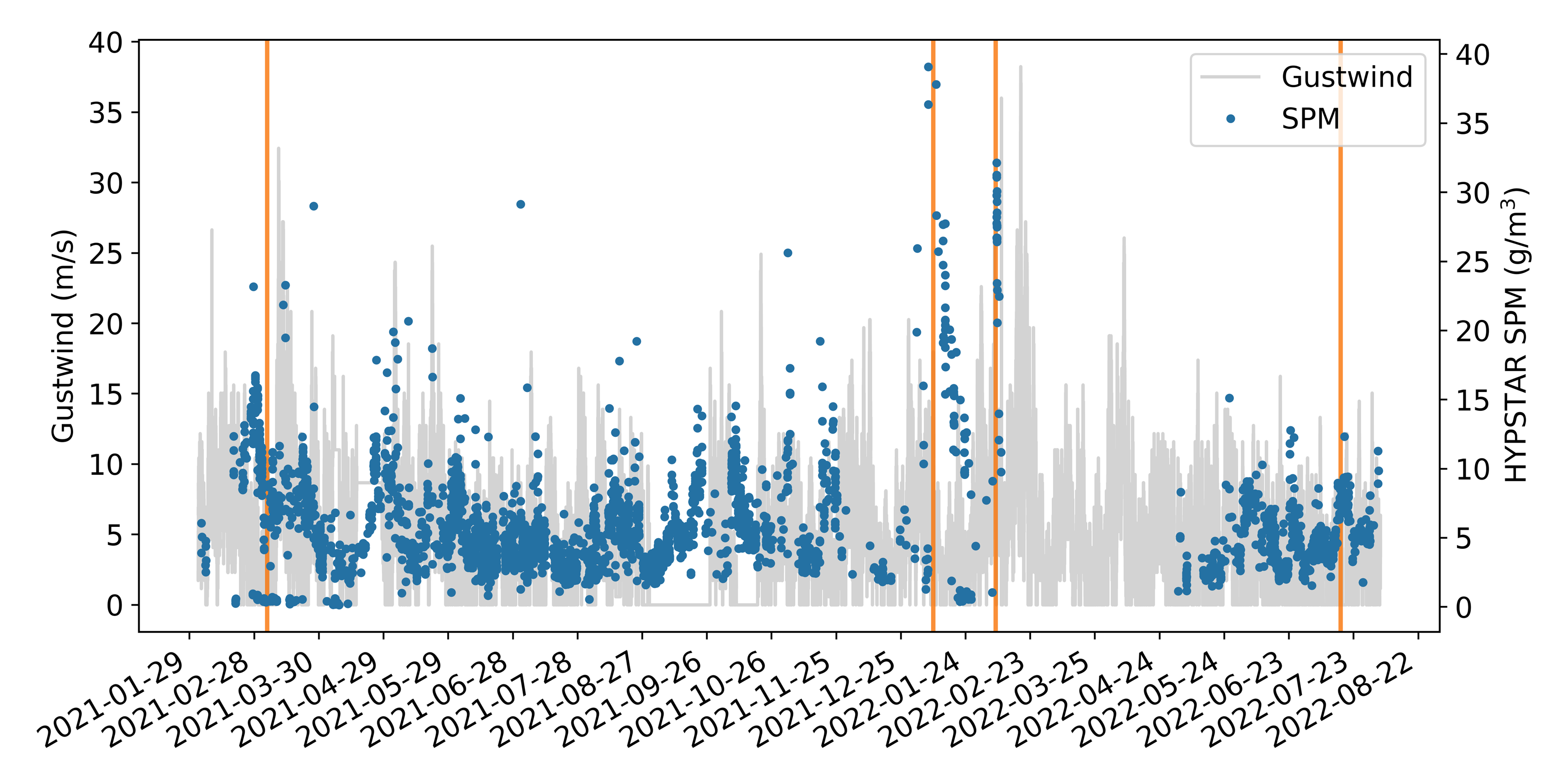
Figure 4 – Time series of SPM (g/m3 ) retrieved with HYPSTAR and gustwind (m/s) (retrieved from the VLINDER station at Blankaart) from January 2021 to August 2022. Source Goyens et al., 2022
Reference
Goyens, C.; Lavigne, H.; Dille, A.; Vervaeren, H. Using Hyperspectral Remote Sensing to Monitor Water Quality in Drinking Water Reservoirs. Remote Sens. 2022, 14, 5607. https://doi.org/10.3390/rs14215607
Goyens C., and K. Ruddick, Improving the standard protocol for above-water reflectance measurements: 1. Estimating effective wind speed from angular variation of sunglint. Appl. Opt. 2023 62 (10), 2442-2455. https://doi.org/10.1364/AO.481787
Project Details
- DateApril 26, 2023
- WriterClémence Goyens and Héloise Lavigne, RBINS
- 1
