Project Description
The digital age has brought about numerous advancements, and one of the most exciting is the fusion of the real and virtual worlds through Augmented and Mixed Reality (MR). The CALLISTO project is at the forefront of this innovation, introducing a MR Application that promises to revolutionize data visualization and 3D content interaction.
What is the CALLISTO MR Application?
The primary goal of the MR Application is to offer a seamless blend of data visualization alongside 3D content reconstructed from the 3D reconstruction server. Here’s a glimpse of its core features:
- Selection of PUCs: Users can navigate through various Pilot Use Cases.
- AR Environment Creation: Craft an augmented reality setting tailored to your needs.
- Dataset Viewing: Choose from a range of datasets for visualization.
- GPS and Non-GPS Modes: Navigate with or without GPS assistance.
- Water Body Data Points: Access detailed information on specific water body points.
- Map Zooming: Dive deeper into the map for a more detailed view.
- Customizable AR View Size: Adjust the AR view to your preference.
- 3D Point Clouds: Experience the 3D reconstructed content.
Algae Animation: Witness the dynamic changes in algae concentration, movement, and turbidity for PUC2 data.
A Sneak Peek into the UI Design
The application’s user interface was meticulously crafted using Figma, ensuring a user-friendly experience. From the login screen to data visualization, every aspect has been designed with the user in mind. Whether you’re observing algae detection in GPS mode or viewing air quality levels with point clouds, the MR Application promises a visually enriching experience.

Figures 1, 2: UI Designs
Getting Started with the App
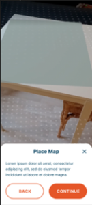
For those eager to dive into this MR experience, the app is currently available for closed testing on the Google Play Store. And will be made live for everyone later this year. Below you can see the screenshots of the application.
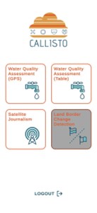
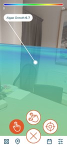

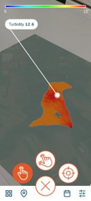
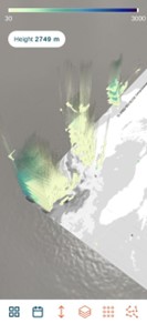
Figures 3,4,5,6,7: UI Designs
What’s Next for the CALLISTO MR Application?
The journey doesn’t end here. The team is gearing up to integrate the MR Application with the CALLISTO User Management system, ensuring seamless interaction with the entire platform. Plans are also underway to enhance the application’s immersiveness and information awareness. This includes juxtaposing air quality height information with renowned landmarks and incorporating 3D city data for satellite journalism. Moreover, the team is focused on developing 3D models tailored for Land Border change detection, aiming to cater to the PUC4 use case users.
