Project Description
When it all began
On 19 May 1998, only a few months after the environmental commitments of the Kyoto Protocol, representatives of the European space industry, under the guidance of the European Commission, signed a declaration known as the Baveno Manifesto, inviting Europe to organize a global Earth observation and environmental monitoring capability and therefore giving birth to GMES (Global Monitoring for Environment and Security). At the start of operations, GMES was renamed the Copernicus Programme in 2012: an independent European Earth observation system delivering data and services to monitor the state of the environment on land, at sea and in the atmosphere and also to improve citizens’ security.
Discovering Copernicus
Coordinated and managed by the European Commission, with the European Space Agency responsible for the space component, Copernicus is today the largest environmental monitoring programme in the world.
It provides data from a family of satellites which are called the Sentinels, eight of which have already been launched (the first one, Sentinel 1A, in 2014), with further expansion missions planned and under study. The Sentinel satellites are all different: they carry various instruments on board, optical as well as radar, and allow a thorough monitoring of different environmental measures.
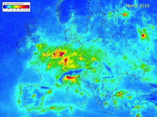
The effects of the coronavirus lockdown on air quality: a comparative analysis of Sentinel-5P TROPOMI data measuring the presence of nitrogen dioxide (NO2) in the atmosphere before and during the lockdown in Europe.
Copernicus also provides Information Services based on the integration of satellite data with in-situ data coming from ground-based, airborne and seaborne measurement systems, which address a variety of application fields: atmosphere, marine, land, climate change, security and emergency.
All of these observations of the Earth – made up of data and information – produce 12 terabytes of data per day. Now 1 Terabyte is equal to 1 million Megabyte: this can give an idea of the amount of data that the Copernicus programme provides on a daily basis, and also an idea of the amount of archived data that is available.
And there is more: all Copernicus data and services are available to anyone, anywhere in the world, on a full, free and open basis.
The DIAS coming into play
The huge amount of available data, products which are often very large in size, the data processing needed to extract valuable information causing further download and storage issues for the users and, last but not least, the ever increasing demand to exploit the free data were the main challenges to tackle.
As a result, the European Commission triggered the DIAS initiative: the set-up of competitive Data and Information Access Services having the aims to facilitate and standardise access to the free Copernicus data, increase the exploitation of these data and boost business, research and innovation.
On 20 June 2018, on the occasion of the 20th anniversary of the signature of the Baveno Manifesto, four DIAS were launched, to which an institutional fifth DIAS was added shortly after: five cloud-based platforms to provide centralised access to the full set of Copernicus data and information and also processing tools, therefore allowing to process data locally without the need to download bulky files from several access points. The aim of the DIAS, offering scalable computing and storage resources at competitive commercial conditions, is to make it easy for users to develop and host their own services and applications, creating new business models based on Earth observation data and information. The DIAS have the ambition to address a wide public, from public authorities to service providers, start-ups, developers, reserachers and the general public, who are the ultimate beneficiaries of the Copernicus programme.
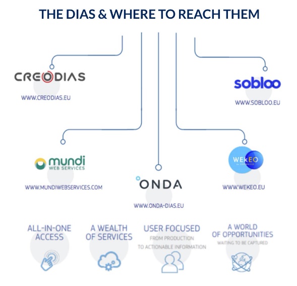
Introducing the ONDA DIAS
ONDA is one of the five DIAS providers, and in line with the European Commission’s objectives, has the goal to “bring people on data”. The ONDA offer includes:
Data Access: the full archive for all Copernicus Sentinels data, Coperncius Information products, data from other Earth observation satellite missions (Envist and Landsat 8) and also access to commercial Very High Resolution (up-to-30 cm) imagery
Cloud Resources: a variety of cloud computing solutions that are scalable, easy to set up and with optimised and consistent performance, also including pre-installed software tools;
Support Services: customisable, managed support solutions and a Service Desk available to provide assistance and technical help.
Moreover, with the aim to support users at various levels of expertise, ONDA provides a series of additional services that include a customized data access system and optimized storage (MOST), an interactive web-based platform of Earth observation products discovery, manipulation and visualisation via Jupyter Notebooks (CLEOPE), and ONDA 4 Education, an initiative for all users, from beginners to trainers, demonstrating, via various training formats, how the ONDA infrastructure is easily used to process Copernicus Sentinel data.
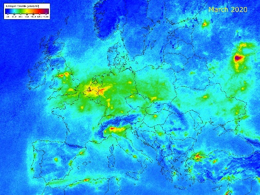
The effects of the coronavirus lockdown on air quality: a comparative analysis of Sentinel-5P TROPOMI data measuring the presence of nitrogen dioxide (NO2) in the atmosphere before and during the lockdown in Europe.
And how does CALLISTO fit in all this?
CALLISTO aims to further extend the concept of the DIAS: the project will be using ONDA to index Earth observation data (already part of the DIAS) with other heterogeneous, unstructured data sources that will be geo-referenced, for example Galileo signals from mobile applications, video recordings from drones, in situ remote sensing sensors and also web and social media data. And it’s going to provide, through the use of Artificial Intelligence (AI) techniques, a Big Data platform tested on use cases relative to policymaking, water management, security and journalism.
So who’s going to benefit from CALLISTO? The Copernicus programme – as the AI solutions will add value to the large volumes of satellite data coming to Earth from the Sentinel constellation –, the DIAS themselves – as a new model of exploitation will be employed –, but above all the end users, who will be able to take advantage of the CALLISTO visual output offered through interactive interfaces, i.e. mobile and Mixed Reality apps, that allow an innovative access to effective information.
Project Details
- DateApr 26, 2021
- WriterBarbara Scarda, Serco Italia
- 5
