Project Description
Thanks to the Sentinel missions nowadays, there are terabytes of available data with a free, full and open data policy adopted for the Copernicus programme. These data can be applied in several thematic or cross-cutting domains. The huge amount of data has created a hub of information that can be fundamental for instance to perform change detection using two or multiple satellite imagery. The concept of change detection can be defined as the process of identifying differences in the state of an object or phenomenon by observing it at different times [1] and can be applied to multiple subjects. In the security domain it has an intrinsic sensitivity in the definition and practical implementation of these objects or phenomena.
With the proliferation of satellite optical imagery (and more recently SAR imagery), the security services associated with imagery intelligence have started becoming available to the broader user base of security professionals (example, imagery analysts), as well coast and land border guards and law enforcement agents. An important catalyst to this change was the introduction of the Security Services [2] in the Copernicus portfolio based on three axis (Border and Maritime Surveillance and Support to EU External Action).
Within CALLISTO SatCen is enrolled in the Pilot Use Case 4 (PUC4), based on the exploitation of unknown signals in a dataset that might be relevant for further consideration and analysis (Figure 1).
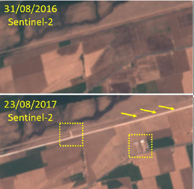
Figure 1 – Change Detection (New buildings, fence and road clearing).
The CALLISTO platform will be able to process Sentinel data, perform accurate land change detection to infer relevant changes at borders (Figure 2) and deliver alerts to the analysts. The foreseen changes in the CALLISTO platform aim to detect not only a spectral/thematic component, but also a context/geospatial component. As regards the spectral/thematic component, in general terms, we are looking for relevant land cover changes besides other potential scenarios such as burnt scars on forests or flooded areas near river-defined borders that might also be considered relevant if they are in the vicinity of the borderline. The second important component that we define is the context/geospatial component, which refers mainly to the distance of an event from the borderline. We also note that in case of land borders defined by water bodies (e.g., rivers or lakes), we measure vicinity starting from the riverbank or shore.
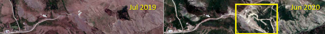
Figure 2 – Change Detection (Construction Site).
As end-users, Image Analysts want to collect land change signals near EU borders as well as their monitoring requirements. They expect to have accurate detections of changes at the EU land borders in order to assist their analysis and take further decisions. The vision is that at the end of the process, the Image Analysts will have effectively used the automation provided by CALLISTO to monitor an area of interest and certain decisions can be made as a result (e.g., decision to monitor the area with better resolution products).
In the scope of CALLISTO, the focus lies on several different cross border areas. Contractions, land clearings and new developments in this area are taking place at various paces. Understanding the impact that these developments will have in the border security is the main objective. The Image Analysts will use the CALLISTO platform to submit an underlying task for change detection for a period of time. As new images will become available, the CALLISTO platform will automatically search, obtain and process them, issuing the corresponding alerts.
References
[1] Singh, A.: Digital change detection techniques using remotely‐sensed data. Int. J. Remote Sens. 10(6), 989–1003 (1989)
[2] Copernicus, Security, https://www.copernicus.eu/en/copernicus-services/security
Project Details
- DateMarch 31, 2022
- WriterPatricia Romeyro & José Santos, European Union Satellite Centre (SatCen)
- 4
